Drone Regulations + Insurance: What Clients Should Actually Ask About
FAA Part 107, Remote ID, LAANC authorizations, $1M liability, and what a certificate of insurance actually covers, the non-boilerplate version.
Most clients don’t come to a drone shoot with regulatory questions. They come with a listing to film. But the two are connected, and the gap between a properly credentialed commercial operator and someone flying a consumer drone for cash is significant, in liability exposure, in airspace legality, and in what happens if something goes wrong.
This post is the non-boilerplate version: what the regulations actually require, what insurance actually covers, and what questions are worth asking before you hand over access to a property.
FAA Part 107, the baseline credential
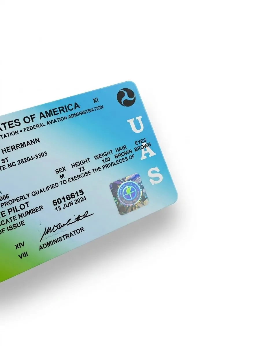
Commercial drone operations in the United States are governed by the FAA under Title 14 of the Code of Federal Regulations, Part 107. Any operator flying a drone for hire, for real estate media, commercial content, event coverage, anything where money changes hands, must hold an FAA Part 107 Remote Pilot Certificate.
Getting Part 107 isn’t a formality. It requires passing a proctored aeronautical knowledge exam at an FAA-approved testing center, passing a TSA security background check, and registering with the FAA’s Drone Zone system. The certificate is valid for 24 months, after which the pilot must complete recurrent training to remain current. Part 107 covers airspace rules, weather minimums, operating limitations, and the legal framework for what commercial drone operations are and aren’t permitted to do.
Every pilot on the OSDT team holds a current Part 107 certificate. It’s the floor, not a differentiator, any commercial operator you hire should have it. If they can’t produce a certificate number, they’re flying illegally.
Remote ID, mandatory since March 2024
Remote ID is the drone equivalent of an aircraft transponder. Since March 16, 2024, the FAA has required full enforcement: any drone between 0.55 and 55 pounds must broadcast its identification, current location, and the location of its control station in real time during every flight. No exceptions outside of FAA-designated identification areas.
The broadcast is transmitted wirelessly on standard radio frequencies, readable by nearby smartphones and government receivers without any internet connection on the drone’s end. The practical effect is that law enforcement, FAA inspectors, and other authorized parties can identify any drone in flight and trace it back to its registered operator.
Remote ID exists partly for accountability and partly as infrastructure for future airspace integration. For clients, it matters because an operator running a drone without Remote ID compliance is running an unregistered, untraceable aircraft, which compounds the liability picture significantly if something goes wrong on your property.
All OSDT aircraft broadcast Remote ID on every flight.
Airspace and LAANC, what Charlotte specifically means
The FAA divides US airspace into classes, and the class a drone is flying in determines whether the pilot needs advance authorization. Class G airspace, rural and uncontrolled, is the simplest case: fly at or below 400 feet AGL, no authorization required. Class B, C, and D airspace, controlled airspace around commercial airports, requires explicit authorization before the first motor spins.
Charlotte is mostly Class B airspace because of CLT’s footprint on the west side of the city. That includes most of the neighborhoods we shoot: South End, Dilworth, Myers Park, Ballantyne, University City, and the surrounding corridors. Flying anywhere near CLT without authorization is a federal violation, not a gray area.
The practical tool for getting that authorization is LAANC (Low Altitude Authorization and Notification Capability), a system the FAA runs through a network of approved apps. A pilot submits a flight request with location, altitude, and time window; the system cross-references the UAS Facility Map for that airspace grid and either approves it near-instantly or flags it for manual review. LAANC requests can be filed up to 90 days in advance, and most Charlotte residential requests resolve in under two minutes.
We file LAANC authorizations for every shoot that falls in controlled airspace. Clients don’t need to do anything, but it’s worth knowing that a part of our pre-shoot prep for most Charlotte listings is an airspace check and, if needed, an authorization request that’s on file before we arrive.
Altitude limits and what they actually mean
The standard ceiling under Part 107 is 400 feet AGL, above ground level, not sea level. There’s one notable exception: if you’re flying within 400 horizontal feet of a structure, you can fly up to 400 feet above the structure’s highest point. That’s relevant for multi-story buildings, rooftop shoots, and construction progress documentation where the shoot itself is elevated.
For residential real estate work, we’re operating well below 400 feet the vast majority of the time. The exterior aerial pass on a typical listing is 150–250 feet. The indoor FPV tour is at flight height, typically 4–8 feet off the floor. Altitude limits are almost never the constraint on a listing shoot, airspace authorization is.
Insurance, what $1M liability actually covers
Drone insurance covers third-party bodily injury and property damage caused by the aircraft during operations. The policy doesn’t cover the drone itself (that’s hull/equipment insurance, a separate product), it covers damage the drone does to things and people that aren’t the drone.
A $1M liability policy means the insurer will pay up to $1 million per occurrence for covered claims, damage to the structure, injury to a bystander, damage to a neighboring property from a flyaway, that kind of scenario. For most residential and commercial listing shoots, $1M is the appropriate floor. Some corporate clients and property managers require $2M.
OSDT carries $1M liability insurance through SkyWatch.ai on every shoot, underwritten by Starr Insurance. SkyWatch operates on a digital-first model: policy documents and certificates of insurance are generated directly from the app, which means turnaround on a COI request is the same day in most cases.
Certificates of Insurance, what to actually ask for
A certificate of insurance (COI) is a one-page document issued by the insurer that summarizes the coverage in force: the policy type, the liability limit, the effective dates, and the named insured. It’s how you verify that a contractor is actually covered before they start work on your property.
For drone operators, clients can ask for a COI as standard practice before any shoot. If the shoot is on behalf of a brokerage, a property management company, or a corporate client with its own risk requirements, they can also request an additional insured endorsement, which adds the client’s entity to the policy for that shoot, giving them direct standing to make a claim if something goes wrong.
We provide COIs on request. Standard turnaround is same-day. Additional insured endorsements are available for corporate and venue clients who require them.
What to ask before you hire a drone operator
The regulatory picture has enough moving parts that vetting an operator isn’t obvious. The short list:
“Are you Part 107 certified?” Ask for a certificate number. It’s verifiable in the FAA’s public registry. Any hesitation here is a red flag.
“Do your aircraft have Remote ID?” Required since March 2024. A no means the aircraft is non-compliant.
“Do you carry liability insurance?” Ask for the limit and ask to see a current COI. The policy should be active, not a screenshot of something from two years ago.
“Do you file LAANC authorizations for controlled airspace?” For Charlotte listings, this is relevant on most shoots. An operator who doesn’t know what LAANC is has never shot a commercial job near an airport.
“Can you provide a COI naming my brokerage as additional insured?” Standard request for brokerages with compliance requirements. Most insurers process these at no additional charge.
These aren’t trick questions. They’re the same questions a general contractor would expect to answer before working on a listed property. A credentialed, insured operator will answer all of them in under a minute.
What compliance looks like in practice
On a typical OSDT residential shoot:
- Every pilot on the job holds a current FAA Part 107 certificate
- All aircraft are registered with the FAA and broadcast Remote ID throughout the flight
- We run an airspace check during pre-shoot planning; if the listing is in Class B (which is most of Charlotte), we file LAANC authorization before arriving
- We carry $1M liability through SkyWatch.ai, with COIs available same-day on request
- If a listing is in the approach path for CLT or another controlled field, we verify ceiling authorizations match our planned altitudes before the rig leaves the case
None of this is complicated. It’s the baseline for operating legally and professionally in a major metro airspace. The reason it’s worth spelling out is that the barrier to entry for flying a consumer drone is low, and the difference between a registered commercial operator and someone offering “drone photos” on Facebook isn’t visible until something goes wrong on your listing.
If you’re booking a shoot and have compliance questions before you confirm, you can reach us directly at contact@oneshotdronetours.com or through the residential page booking portal. COI requests for existing clients go to the same address, we’ll have it in your inbox the same day.
Related journal posts
The State of Commercial Drone Regulation After 2025
The state of US commercial drone regulation in 2026. Remote ID fully enforced, Part 108 BVLOS rulemaking active, LAANC ecosystem maturing, and what commercial operators should track through 2027.
The OSDT Equipment Guide: Every Rig We Fly and Why
The complete OSDT equipment breakdown: FPV rigs, gimbal systems, cameras, radio links, editing stack, and field infrastructure. What we fly, what we shoot with, and the logic behind each choice.
ANSI Z765 Floor Plans for Charlotte Listings: When the Tax Record GLA Is Wrong
ANSI Z765 is the measurement standard that turns a 2D floor plan into a defensible GLA on the listing. On Charlotte's older homes, additions, and rebuilds, the tax record number is rarely right.